Washpool Creek Master Plan: Transforming Bundaberg’s Waterway for People and Nature
Words — Tract
Images — Tract
Category — Insights, Projects
Client — Bundaberg Regional Council
Collaborator — E2 Design Lab
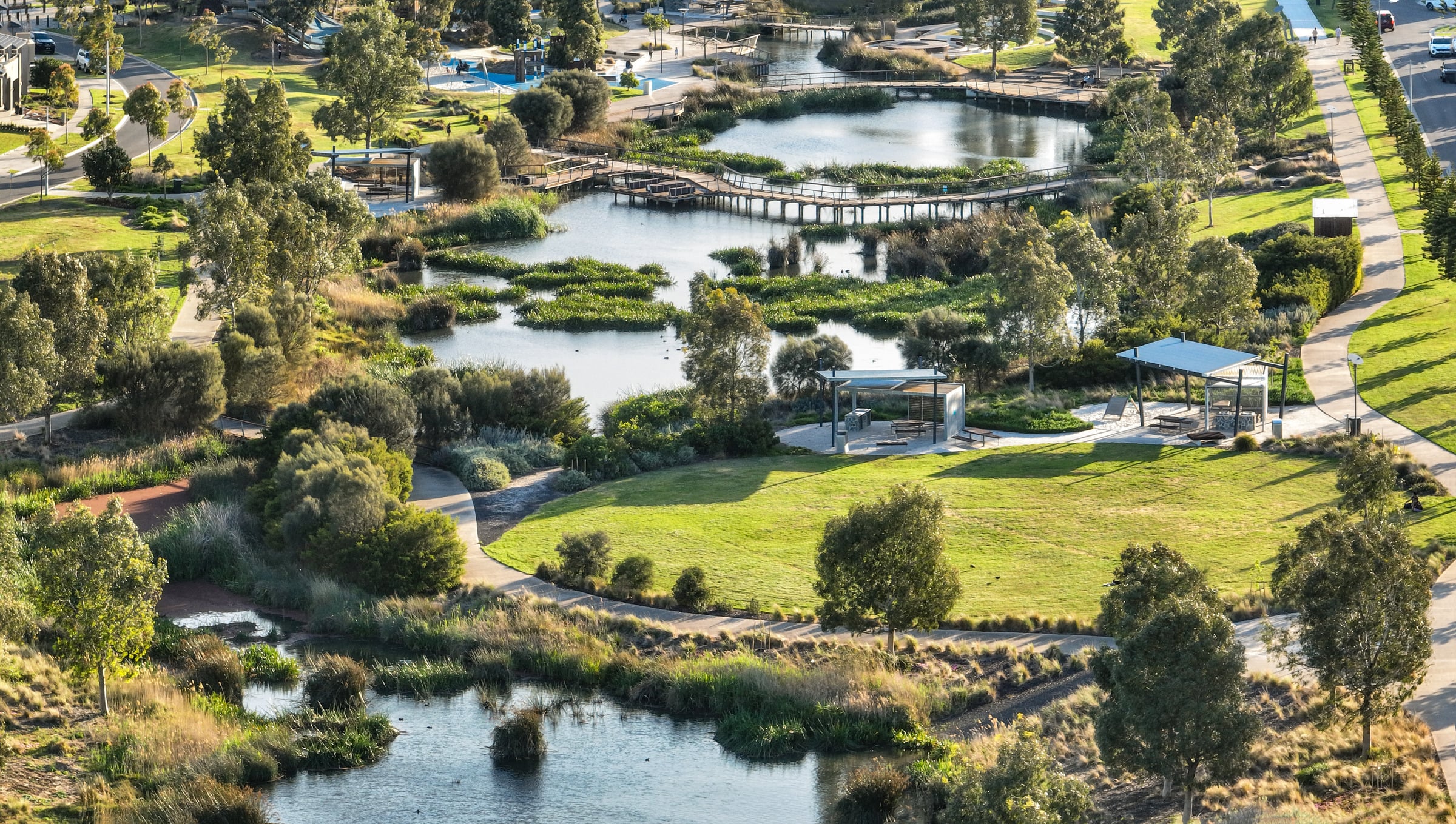
The Washpool Creek Master Plan reimagines Bundaberg’s urban waterway as a resilient, biodiverse corridor that reconnects the community with water, nature, and culture.

Tract was commissioned by Bundaberg Regional Council, to guide future urban development, stormwater infrastructure renewal, and ecological rehabilitation across a highly urbanised catchment.
The Master Plan sets a visionary 30-year framework balancing rigorous technical requirements with bold urban design ambitions, creating a roadmap for a resilient, biodiverse, and community-connected waterway.
A highly urbanised tributary of the Burnett River, Washpool Creek has undergone profound change since European settlement. Historically, the catchment supported eucalypt woodlands and freshwater wetlands, including what is now Baldwin Swamp, providing food, water, and social value for the Taribelang Bunda, Gooreng Gooreng, Gurang, and Bailai (Byellee) Peoples for thousands of years. Colonisation dramatically altered the landscape, with thick vine scrubs cleared, freshwater swamps drained, and natural creeks channelised to maximise land development and flood conveyance.
Understanding Washpool Creek’s Transformation
By the mid-20th century, most of Washpool Creek and its tributaries had been converted into concrete channels. While these grey infrastructure works efficiently transported stormwater, they also constrained the waterway, degraded water quality, reduced ecological function, and disconnected the community from its natural assets. Recent condition assessments indicate that the concrete channels are showing moderate to severe deterioration, requiring significant replacement over the next 10–20 years.
At approximately 6.54km2 in size, the Washpool Creek catchment includes areas of Bundaberg South, Kepnock, Walkervale, Avenell Heights and Norville. Urbanisation has increased impervious surfaces, producing a ‘flashy’ catchment where rainwater rapidly enters the creek, creating both local and downstream flood risks. Extreme rainfall events – like the 319mm recorded in Bundaberg CBD on 2 October, 2017 – highlight the vulnerability of properties and infrastructure, particularly in the lower reaches near Baldwin Swamp.

A Vision for Resilient Waterways

The Master Plan’s vision reframes Washpool Creek from a drainage conduit to a living, multifunctional corridor. Our team worked closely with Bundaberg Regional Council, Traditional Custodians, and the local community to identify key priorities:
- Flood resilience: Using modern Water Sensitive Urban Design (WSUD) strategies to store, slow, and treat stormwater while reducing community flood risk.
- Ecological restoration: Re-naturalising sections of the creek, reintroducing native vegetation, and increasing canopy cover to 40%, providing shade, improving air and water quality, and supporting fauna.
- Community reconnection: Creating accessible open spaces, active transport corridors, and recreational amenities, linking residents to the creek and each other.
- Water quality improvements: Reducing pollutant loads entering Baldwin Swamp, the Burnett River, and ultimately the Great Barrier Reef.
The Master Plan establishes Washpool Creek as a catalyst for a flood-wise, biodiverse, and socially resilient catchment.
Engaging the Community and Traditional Custodians
Community engagement has been central to shaping the Master Plan. Our team facilitated workshops, online surveys, and conversations with Traditional Custodians, where they shared lived experiences, observations, and cultural knowledge. These insights informed strategies for flood management, ecological restoration, and public amenity, ensuring that interventions respond directly to community needs while respecting cultural heritage.
Traditional Custodians’ input has also guided cultural narrative integration across the catchment, from interpretive signage and walking trails to plant species selection and waterway rehabilitation approaches. This partnership fosters economic self-determination, reconnection to Country, and generational knowledge transfer.

Hydrology, Flooding, and Stormwater Management

The Washpool Creek catchment experiences several different types of flooding, including local overland and creek flooding, storm tide inundation and riverine flooding from the Burnett River. Overland flooding is exacerbated by flat topography and impervious urban surfaces, while riverine and storm tide flooding pose risks in downstream areas of the catchment. Historically, engineered concrete channels prioritised rapid conveyance, and developable land, but contributed to downstream flooding, high water temperatures, and poor water quality.
Our team’s technical analysis focused on understanding:
- The impact of flood likelihood and severity,
- The capacity and condition of existing channels,
- The extent of impervious surfaces,
- Opportunities for WSUD interventions, including swales, sediment ponds, and bioretention systems, and
- Restoration potential to reconnect surface and groundwater systems.
WSUD measures aim to store and slow stormwater, naturally filter pollutants, reduce peak flows, and improve liveability. These interventions provide measurable community, ecological, and climatic benefits, including cooler streetscapes and enhanced biodiversity corridors.
Ecological Rehabilitation
The Washpool Creek catchment currently supports limited habitat, with Baldwin Swamp and a small un-channelised segment of Washpool Creek Channel No. 2 remaining as critical ecological refuges. Concrete channels dominate much of the corridor, transporting sediment, litter, nutrients, and pollutants to Baldwin Swamp and downstream waterways.
Our team proposed a phased creek re-naturalisation program, using selective channel removal, bioengineering, and indigenous revegetation to:
- Reintroduce terrestrial and aquatic habitat for vulnerable and native species,
- Reconnect isolated ecological pockets to allow species movement,
- Restore groundwater recharge, soil moisture, and microclimatic cooling, and
- Enhance visual and amenity values for the community.
Increasing canopy cover within residential streets and public spaces further strengthens ecosystem services, providing shade, reducing urban heat island effects, improving air quality, and supporting active transport uptake.

Catchment-Wide Strategies

Tract’s team has developed an integrated approach across the Washpool Creek catchment, combining waterway, greenspace, streetscape, residential, and governance initiatives. Key actions include restoring and naturalising degraded channels, improving habitat through native plantings, and creating accessible recreational and educational spaces. Streetscapes and residential areas are enhanced with vegetated verges, canopy trees, and permeable surfaces to manage stormwater, reduce heat, and encourage active transport.
Community engagement is central, with programs for schools, citizen science, and local residents to build flood resilience, support biodiversity, and foster connection to the waterway. Policy and technical guidance will ensure these interventions are sustained and aligned with long-term catchment management objectives.
Bringing the Master Plan to Life
Several key precincts will demonstrate the Master Plan’s principles on the ground.
Lamb Street Parklands: Council-owned land along Lamb, Targo, and High Streets will be reimagined as multifunctional green space. Sediment ponds and naturalised creek channels slow and treat stormwater while creating habitat corridors. Elevated boardwalks, interpretive signage, and recreational amenities reconnect the community to the waterway, showcasing modern WSUD principles.
Colman Street: By repositioning the creek between two one-way vehicle corridors, Colman Street will exemplify a water-sensitive streetscape. Active transport corridors, indigenous flora planting, and localised nature-based engineering interventions improve flood capacity, habitat provision, and thermal comfort.
Edwards Street: A parallel vehicle corridor allows pedestrian and cyclist priority, creating liberated public space while implementing WSUD interventions. Concrete channel material is re-purposed to stabilise banks, and indigenous planting enhances ecological function and foraging opportunities for fauna.
Social, Cultural, and Environmental Benefits
The Master Plan envisions Washpool Creek as a living corridor that delivers benefits across multiple scales:
- Community Health: Increased access to shade, waterway engagement, and recreation improves mental and physical wellbeing.
- Education and Storytelling: Indigenous cultural narratives and citizen science initiatives reconnect residents with the waterway and Country.
- Ecological Resilience: Restored habitats, improved water quality, and increased connectivity support native flora and fauna.
- Climate Adaptation: WSUD measures, tree canopy, and green infrastructure reduce flood risk, mitigate urban heat, and enhance liveability.


Looking Ahead
“[Tract's] focus on engagement and innovative stormwater and WSUD strategies has shifted people's perceptions of waterways as just drains, instead encouraging them to view them as important cultural and environmental assets. This project boosts flood resilience, connects habitats, and helps build a healthier, safer, and more climate-resilient community.”
Washpool Creek is being reimagined not merely as a drainage system, but as a resilient, biodiverse, and culturally significant corridor that reconnects the community with its water, land, and shared history.
The project has been recognised by the Australian Institute of Landscape Architects, the Planning Institute of Australia and Stormwater Queensland for its community-led and climate positive strategic planning approach.
Through ongoing community engagement, partnerships with Traditional Custodians, and technically robust WSUD strategies, the Master Plan sets a benchmark for sustainable urban waterway management.
By combining visionary design, technical precision, and cultural respect, the Washpool Creek Master Plan is a catalyst for long-term change, offering Bundaberg a roadmap to a healthier, safer, and more liveable future – ensuring that water, nature, and people thrive together for decades to come.
To find out more about planning and designing for climate adaptation, contact our team.