From Source to Sea: Reimagining Urban Waterways
Words — Clare Mayberry, Climate & Biodiversity Strategist
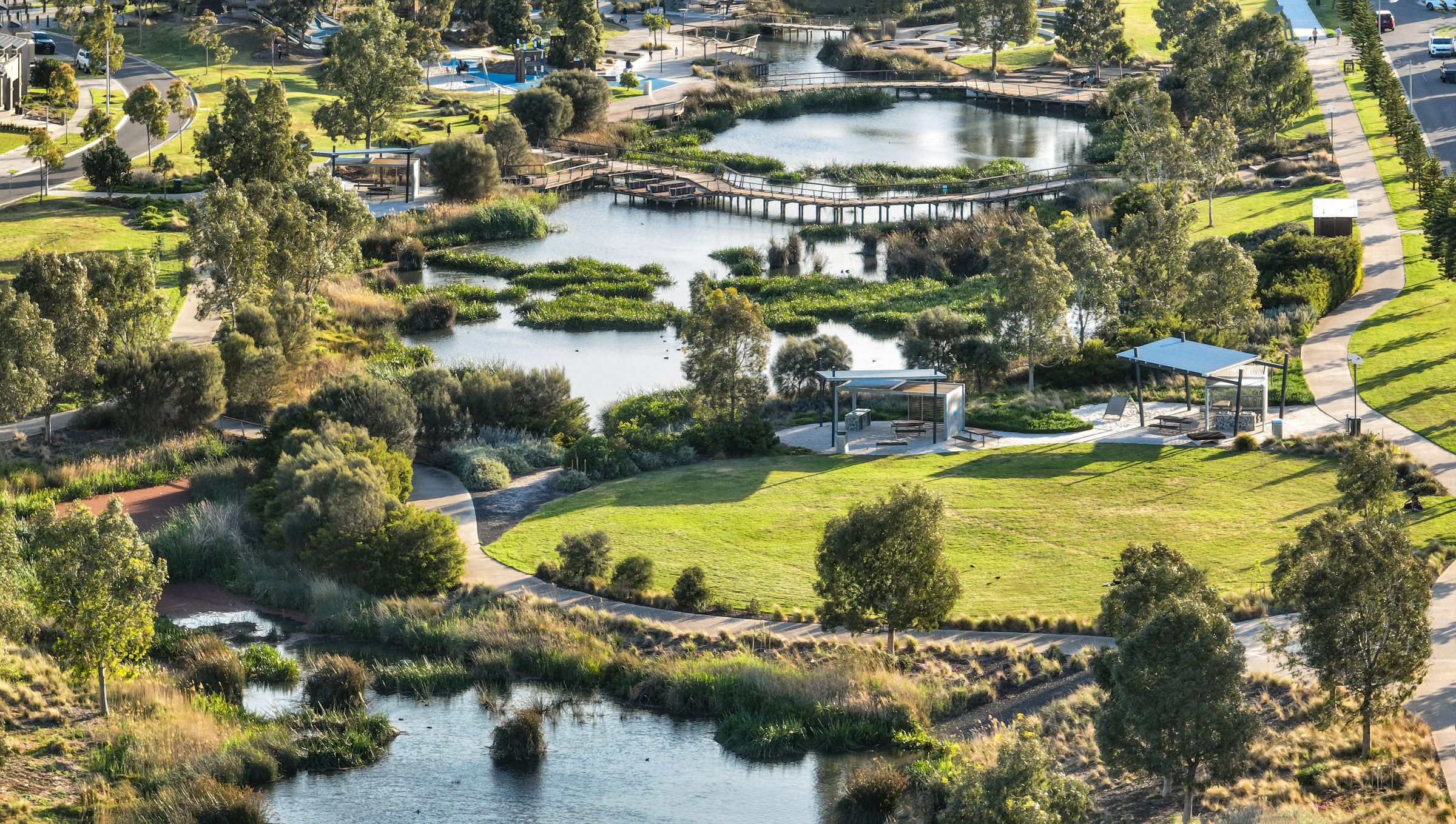
Images — Hanlon Park / Bur’uda: Christopher Frederick Jones
Category — Insights, Initiatives
Channelised, buried or constrained to support urban growth – this is a story common to many waterways across Australian cities. As leading landscape architects, Clare Mayberry, Kylie Jordan and Bridget McGuigan can attest, by reframing how we think about waterways and catchments as part of a bigger urban and natural system, we can better plan and design our approach to urban hydrology at multiple scales, making positive change for cities, people and nature.
The current approach: not-so natural systems
While often perceived as natural systems, the hydrology and ecology of urban waterways has frequently been altered, reducing biodiversity, disconnecting floodplains and limiting the capacity of landscapes to manage water naturally.
The impacts of urbanisation extend well beyond the immediate waterway corridor. As cities expand, impervious surfaces increase stormwater runoff, pollutant loads and altered flow regimes, affecting the health of rivers, estuaries and coastal environments downstream.
Urban waterways are therefore critical connections between cities and their broader catchments, linking local water management decisions with environmental outcomes from source to sea.
Clare Mayberry, Climate and Biodiversity Strategist understands how landscape architecture, urban design and strategic planning play a critical role in shaping the future of urban waterways.
“Working across catchments, corridors and public spaces, these disciplines provide the framework to balance ecological health, flood management, urban growth and community needs. Through long-term planning and design, waterways can be reimagined as multifunctional landscapes that support biodiversity, strengthen climate resilience, improve water quality and create valued public places.”
— Clare Mayberry, Climate and Biodiversity Strategist


Washpool Creek: Masterplanning at catchment and local scales
Approaches such as renaturalisation, creek rehabilitation and river corridor renewal reconnect waterways with wetlands, floodplains and native vegetation, enabling natural processes to slow, filter and retain stormwater while restoring habitat and ecological function. In doing so, degraded drainage infrastructure can be transformed into resilient blue-green corridors that deliver environmental, social, cultural and recreational benefits from source to sea.
The Washpool Creek Master Plan demonstrates this approach in practice. Within the Burnett River catchment, the project responds to ageing stormwater infrastructure, declining waterway health and increasing flood risk by reimagining the creek as a multifunctional blue-green corridor. Creek rehabilitation, revegetation, water-sensitive urban design and public realm improvements work together to enhance flood resilience, biodiversity and community connection to water.
The benefits extend beyond the local corridor. Washpool Creek ultimately drains to the Burnett River and the Great Barrier Reef, linking urban water management with downstream ecosystem health.


The development of a suite of creek channel rehabilitation typologies, ranging from fully naturalised and partially naturalised treatments to more engineered stabilisation solutions, provides flexible responses to varying urban conditions and spatial constraints while enhancing channel stability, ecological function and waterway health.
These interventions help filter and retain stormwater, improve water quality, and support a source to sea approach to catchment management.
Through a coordinated program of ecological rehabilitation, public realm renewal and improved creek access, the master plan re-establishes Washpool Creek as both a healthy urban waterway and a place where the community can connect with water, Country and place.
How the ‘ecological edge’ is reshaping our relationship with water
Delivered with the City of Melbourne, Birrarung Marr – Site One of the Greenline Project demonstrates how rehabilitating the ecological edge of urban waterways can create meaningful outcomes for both people and nature. Along a previously degraded section of the Yarra-Birrarung River, the project re-establishes indigenous riparian vegetation and reinterprets pre-colonial wetland and marshland ecologies to strengthen habitat value and biodiversity while reconnecting people with the river as a living system.
The redesigned river edge incorporates rock crevices, bank edges and revegetated riparian zones that support terrestrial species, semi-aquatic and pollinating species. The project has recently seen the return of the Rakali (Australian native water rat), with designed habitat providing refuge and nesting opportunities for the species.
Since the project was completed in late 2025, Kylie Jordan, Principal Landscape Architect, has observed how the project is already changing the city’s relationship to the river, and its ecology.


“By embedding habitat restoration within an accessible urban public realm, Site One of the Greenline Project demonstrates how landscape architecture can shape resilient waterways that support biodiversity, enhance ecological function and reconnect people with urban river frontages.”
— Kylie Jordan, Senior Principal Landscape Architect

Frameworks for networks: blue-green grids
Another ambitious plan for urban waterway enhancement at a much larger scale is the Georges River Parklands and Chipping Norton Spatial Framework in south-west Sydney. Developed by Tract for Liverpool City Council, the framework establishes a long-term vision for one of Sydney’s most significant blue-green networks, encompassing the Georges River, Chipping Norton Lakes and surrounding parklands.
The strategy identifies opportunities to restore ecological connections, improve river health and expand public access across a highly valued river corridor experiencing significant urban change. Through extensive stakeholder engagement, catchment analysis and strategic planning, the framework guides future investment in green infrastructure, biodiversity enhancement and public domain improvements, demonstrating the critical role that waterway planning can play in shaping more liveable, connected and resilient river cities.


Evolving cities: evidence-based adaptive design
Time is a critical element to determining resilience. It allows us to see how spaces adapt with change, weather events, and contextual impacts from the cities they’re embedded within – in expected and unexpected ways. Measuring the performance of projects and design interventions helps to inform evidence-based advocacy, design solutions and delivery of future urban waterway projects that are truly ‘resilient’.
In collaboration with academic partner Queensland University of Technology and the Landscape Foundation of Australia, Tract is currently evaluating the long-term performance of Hanlon Park/Bur’uda on Norman Creek, a major tributary of the Brisbane River.
Hanlon Park/Bur’uda’s transformation delivered Australia’s largest urban waterway renaturalisation project, replacing a concrete drainage channel with a thriving natural creek corridor. Four years post construction, the research team is assessing environmental performance, flood resilience, community perceptions, recreational use, visitation patterns and user experiences, to better understand how naturalised waterways function and deliver multiple benefits over time.
Bridget McGuigan, Principal Landscape Architect, highlights that, by combining technical analysis and social research, the study is building an evidence base for urban waterway rehabilitation and demonstrating the value of landscape architecture in delivering long term environmental, social and cultural outcomes.


“The benefits of urban nature and renaturalisation are well-understood, but these are complex living systems that change over time, so it’s important to continue evaluating our work so our design process and outcomes can be responsive and adapt as well.”
— Bridget McGuigan, Principal Landscape Architect
Urban waterways as more than just engineering or nature
Together, projects such as Washpool Creek, Birrarung Marr’s transformed ecological edge, Georges River Parklands and Chipping Norton, and Hanlon Park/Bur’uda demonstrate the growing role of landscape architecture, urban design and strategic planning in reimagining urban waterways as multifunctional assets.
By improving ecological function and strengthening community connections to water and nature, these projects deliver lasting environmental, social and cultural benefits while contributing to the long-term resilience and health of catchments and downstream environments from source to sea.
How can Tract assist?
To find out more about designing urban waterways for improved climate resilience, adaptation and biodiversity, reach out to our team.

Clare Mayberry
Climate and Biodiversity Strategist (National)
Brisbane / Turrbal & Yuggera Country

Kylie Jordan
Senior Principal Landscape Architect
Melbourne / Wurundjeri Country